Being Mithridates

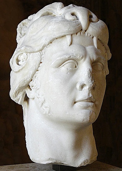
The death of Mithridates VI Eupator, the last king of Pontus, in 63 BC marks both the culmination and the implosion of the dream of an independent Pontic state uniting the shores of the Black Sea under one ruler. Born c. 134 BC in Sinop, Mithridates spent his life pursuing his ambition. He probably saw himself as another Alexander but his roots were hardly Greek. He certainly had deep ties with Persia, beginning with his name meaning ‘gift of Mithras’; the kingdom he inherited may have included a stretch of Black Sea coast but was originally very much an inland state. As for Sinop, that foothold on the coast, it was lost to the Romans in 70 BC and later turned into a colony under the name of Colonia Julia Felix. Mithridates’s relentless pursuit of his destiny—which earned him the respect of modern-day Turks who see him as a national hero who put up a stubborn resistance to foreign (i.e. Roman) interference, as much has Atatürk did after WWI with the Greeks—is well known through the works of Appian on the Mithridatic wars and indirectly from Plutarch’s lives of Pompey and Lucullus. His name also crops up in other contemporary sources, such as Pliny the Elder and Celsus. He was clearly a figure larger than life and though he eventually failed, he held for a while in his rule large chunks of Asia Minor, the eastern and the northern coasts of the Black Sea, until he was defeated and committed suicide. He had already become a legend in is own lifetime, which goes some way to explain why he was honoured with a monument in Delos. It is thought that the Greek priest Helianax saw him as the right character to exhibit in order to improve the cosmopolitan feel of the sanctuary.

Head of Mithridates in the guise of Hercules, in the Louvre. Photo © Eric Gaba.

Mithridates was known not only for his military achievements: he pursued many sidelines. One does wonder how he found the time to take an interest in his six wives (the first one being his sister Laodicea, a choice expressing a very Persian concern with the purity of the line) and numerous concubines. Mithridates was a linguist and prided himself on being able to address each of his subjects in his or her own language. According to Pliny, that required a total of 22 different languages. He also had a fixation on poisons—and quite rightly so. He had witnessed his own father, Mithridates V, succumb to poison at a banquet. Poison or the fear of poison was common in antiquity. So he set about looking for a remedy, and as prevention is better than cure, he hit on the idea of taking regular sub-lethal doses to make himself immune. Celsus thought this method worth including in his publication on medicine. Moreover, in his quest for an antidote Mithridates made his name in the field of botany (a couple of plants are named after him). Pliny himself, however, did not think much of his universal antidote made of dried walnuts, figs and rue pounded together with a pinch of salt, nor of the enhanced version with 54 different ingredients.

After a spell in the wilderness at the end of the Classical era, Mithridates re-emerged as one of the illustrious men whose fates Boccaccio wrote about in the early 14th century. At the beginning of the 17th century an unknown Italian cleric composed a tragedy about him; this found its way to the French court and eventually inspired Racine. His Mithridate, a tragedy of love, jealousy and treachery, was a hot favourite with Louis XIV; the Mithridates Riding to Battle with his Concubine Hypsicratea, which Antoine Paillet painted at Versailles in 1642, is probably no coincidence. Racine’s work was translated into Italian by Parini and Alessandro Scarlatti put it to music. The première was held in Venice in 1707. After that, libretti and operas on the tragic king multiplied. There were some 25 of them floating around when Mozart set about writing his own Mithridates King of Pontus in 1770. It was his first opera seria and was an instant success. He was barely 14.

Paola Pugsley’s Pontic Provinces of Turkey will be published by Blue Guides as an ebook later this year. Her Blue Guide Southeastern Turkey and Blue Guide Eastern Turkey were published last year. See here for details.

Copyrighting Heritage

I enjoyed David Miles’ article on Stonehenge in this month’s Minerva magazine. I remember visiting Stonehenge in the autumn of 1978. I was almost the only person there. I don’t remember any fences. I walked right up to it. I touched the stones. I took pictures of it. I have never been since, though I have glimpsed it from the A303. Noticing that all the photographs in the Minerva article were copyrighted to English Heritage, I thought I had better look again at EH’s statement about copyright, since it has been in the news lately. If I were to dig out one of my old 1978 photographs and then print it in a forthcoming Blue Guide, would I have committed a felony?

This is what they say, on their website:

Well, it’s generous of them not to have a problem with photographers sharing images on not-for-profit websites. Not that Flickr is quite the sharing experience it used to be, since now you have to sign up before you can see anything. But woe betide anyone who enters English Heritage land ‘with the intention of taking a photograph for financial gain…’ Filthy financial gain! Could any photographer have such dastardly intent? But what if I took a photograph of Stonehenge, not with loathsome lucre on my mind but with the intention of illustrating a Blue Guide? Would I still have to pay to use my photo, even though no one is paying me to reproduce it and the book is a costly-to-produce printed guide aimed at encouraging people to visit the site?

I don’t think the demonising of ‘profit’ is helpful. Without it, there is no culture or civilisation. Even not-for-profit organisations are reliant on profit. The funding they get comes from profit that someone else has made somewhere else on something else at some other time. For now, I’ll avoid reproducing images of English Heritage sites, because I don’t want any hassle. But I do want to help photographers to make a living. Yes, financial gain. For talented, creative people. Sharing stuff around the campfire is fine, but it doesn’t lead very far. And anyway, how can you fairly and squarely copyright HERITAGE?

Stonehenge at the solstice. For copyright reasons, this image cannot be displayed.

Under Another Sky

Charlotte Higgins, Under Another Sky: Travels in Roman Britain. Jonathan Cape, London, 2013. Reviewed by Charles Freeman.

If I am heading westwards from my home in central Suffolk I go along a stretch of Roman road and eventually reach the village of Stonham Aspal. To the far side there is a ridge overlooking open countryside and it is here that a Roman bathhouse was discovered in 1962, when building work was being done for some bungalows. It was my first dig, with a tolerant Ipswich Museum team interpreting laws against child labour generously enough to allow a fourteen-year-old to shovel out ashes from a Roman hypocaust. The main part of the villa is assumed to have been on the other side of the road and remains unexcavated, but I still tell the story to anyone I am driving that way.

The pottery from the site is of the 3rd and 4th centuries, the greatest period of the British Roman villa. This was the time of prosperity before the collapse of Roman rule in the early 5th century brought a devastating fall in living standards (apparently as a dramatic as anywhere else in the western empire). Looking back, I wonder what the ashes I scraped out could have told of the final fires lit to heat the baths. There was no one on hand to record the last days of the empire in Britain but gradually the cities, already faltering in the 4th century, were abandoned and the great buildings fell in or were buried. One of the most evocative finds has been a luxurious Roman villa on the London waterfront that enjoyed a heyday in the 3rd century but then began to crumble, although 200 coins dated as late as ad 388 talk of a late burst of occupation.

Charlotte Higgins’s delightful book is an account of her searches for Roman Britain in the company of her boyfriend Matthew and a venerable and resilient camper van. Higgins read Classics at Oxford so she knows her sources—predominantly those of the finest Roman historian—Tacitus, and she weaves them gently into her itineraries. She has also absorbed those who have been before her: William Camden, the author of Britannia (1586), the first quasi- scientific study of British antiquities, and the polymath William Stukeley (1687–1765), who recorded what stood of Silchester, Hadrian’s Wall and other sites. Stukeley, a fan of the Druids, was sadly taken in by a fake history of Roman Britain purporting to have been written by one Richard of Westminster in the 14th century. Stukeley’s enthusiastic support for it meant that it was treated as authentic and Roman history distorted until well into the 19th century. The Pennine chain of hills take their name from the pseudo-Richard’s description of them.

Gradually out of these forays into a misty past, archaeologists took over. So here is Mortimer Wheeler and his much put-upon wife Tessa, bringing military precision to excavations of St. Albans and later, and most famously, of the Iron Age fort of Maiden Castle. Wheeler revelled in describing the last stand of the British against Roman onslaughts and the mass grave into which the defeated British were thrown. Unfortunately, more recent work queries whether the cemetery was ever a mass grave at all; but the story gripped me as a teenager. By the 1970s, we arrive at more delicate work, especially with the writing ‘tablets’, actually slivers of wood, from the Roman fort at Vindolanda, miraculously preserved in waterlogged ground. Excavated by Robin Birley and deciphered by Alan Bowman, they provide an astonishingly graphic account of everyday life on the frontiers at the end of the 1st century ad, as invites go out for birthday parties and details of which men are available for outside work are painstakingly extracted from the intricate lettering.

Higgins also ventures further north to discover reminders of the short-lived invasion of Scotland by Agricola in ad 79 or 80 (we know of it because the historian Tacitus was Agricola’s son-in-law and left a vivid account) and the little-known Antonine Wall, held only briefly before the frontier was pulled back again to the better-known barrier built by Hadrian. She takes in Bath and York, the latter achieving an empire-wide status when the emperor Septimius Severus established his court here between 208 and 211 and when, a century later Constantine, the first Christian emperor, was proclaimed emperor by his father’s troops. In Bath the Romans adopted the local Celtic god Sulis, associated her with their own Minerva, and the temple dedicated to both presided over the hot springs that were to set Bath up as a watering place in later centuries. In Colchester and London, dark layers record the burning of the nascent Roman settlements by the furious Boudica, in a devastating but ultimately crushed campaign (ad 60 or 61) that also survives in Tacitus’ account.

I am sorry that the camper van, with ‘its many and varied complaints’, did not merit an entry in the index. I would have liked to have retraced its valiant hill climbs even if it did collapse in York and thus not quite make it to Hardknott Castle (a 2nd-century fort guarding Hardknott Pass), perhaps the most spectacular of all the Roman sites in Britain. It added character to what is an engaging survey of our Roman past. While Higgins records exhaustive studies of Roman Britain (Roger Wilson’s A Guide to the Roman Remains in Britain and the mammoth four-volume compilation of every known Roman mosaic by David Neal and Stephen Cosh), she provides a more light-hearted account, a valuable reminder of how the Roman past lies not too far beneath our feet. Indeed a metal detector unearthed a worn Roman coin from our own fields just a year ago, and, this being Suffolk, perhaps another Mildenhall treasure, the hoard of astonishing silver plate unearthed in 1942, is just waiting to be discovered close by.

Under Another Sky was shortlisted for the Samuel Johnson Non-Fiction Book of the Year Award.

A trip to the Port of Trajan, outside Rome

We were lucky to get into the area of the old Port of Trajan, just south of Fiumicino airport. The website states that it is “open” between 9am and 1pm on the first Saturday and last Sunday of the month, and gives a Google map with a pin stuck in it close to the Parco Leonardo railway station. So we took a train there, on the first Saturday of the month, and arrived shortly after nine thirty. No museum in sight. I rang the number and was told that the guided tour had already begun, that there was no way we could join, that in any case a prior booking was necessary. We could come back on the last Sunday of the month. “No,” I said, “you don’t understand. I’ve NEVER been in Rome on the right day of the month before. This time I am! It’s my only chance! We really want to join the group. Tell us where they are!” We set off on foot, along the busy Via Portuense, with the prospect of several kilometres to go, narrowly missing being flattened by trucks. Then a godsend: a man stopped and gave us a lift. The entrance gate was just under a motorway flyover (marked A on the map). By extraordinary good fortune, the tour was just inside the gate, inspecting the remains of what had once been a portico fronting a line of granaries belonging to the old Port of Claudius.

The ports were laid out here in the 1st and 2nd centuries AD, first by Claudius and then by Trajan. The sea has retreated some three or so kilometres west since then, and most of the area has dried out or been drained, but some of the old contours remain. The grain stores, though overgrown with weeds, still clearly retain parts of their old flooring, built up on brick stilts known as suspensurae, a device designed to minimise damp.

Suspensurae in the floor of an old warehouse

Claudius’ port was, in its heyday, the largest in the Mediterranean, with 800m of wharf. But it was unsheltered and very vulnerable to storms. In AD 62, for example, 200 ships at anchor were wrecked in a gale. The complex was altered, with a new harbour further inland, by Trajan. We left the Claudian area by means of a short colonnaded street (B), with a double enfilade of chubby travertine columns running up it. On one side we were shown a brick archway filled in with bricks arranged in the crosswise opus reticulatum pattern. The archway was never open, the guide explained. It was placed there to give greater strength, to direct the downward thrust of the wall outward to the buttressing piers on either side, at a point where there is no stable ground directly underneath. We were also shown two pieces of fallen travertine column. One of them, a capital, had two iron pegs sticking out of its underside. It was with these that the capital was fixed to the block below it, but with a “glue” of molten lead, which was poured in along specially cut runnels (shown in the next illustration). Lead, unlike iron, has a certain amount of elasticity, which can better withstand seismic shocks.

At the end of the colonnaded street we turned right, to the site of the old Darsena, Trajan’s inner harbour (C). There is little to see now but a reed-filled marsh, but at one side the stone harbour wall can be seen. Analysis of the warehouses that stood alongside this harbour has shown that the stores of marble, the heaviest item to move, were—perfectly logically—placed closest to the dock. On the further side were warehouses that had possibly held grain, or some other commodity sensitive to damp, since the walls had been coated in a layer of pozzolana, a waterproof cement made from a mixture of lime and volcanic ash.

View of the Darsena

From here we walked out onto a broad, flat path, grass-grown now—though once it had been filled with water, for this was the channel (D) that linked the old Port of Claudius with the hexagonal Port of Trajan. It is wide enough for several ships to have passed along it at once. At its far end we could see the remains of large warehouses (E). We turned past them, onto a narrower path (F), again once a water channel linking the harbour complex with the Fossa Traiana, the canal that Trajan dug to link his port to the Tiber.

We were all impatient to see the famous hexagonal port, but there was wildlife to be admired: a herd of fallow deer; enormous funghi that were erupting from the soil practically before our eyes; a long black-and-yellow chequered snake; and scatterings of porcupine quills. The land is a bit unkempt. Much of it belongs to the Torlonia family. It could be a magnificent park, if time, energy, money and enthusiasm could be found…

Part of the hexagonal basin is flanked by warehouses of the Severan period, probably built during the reign of Antoninus Pius. It was possible to climb onto a sort of viewing platform, to get a glimpse of the basin (G). But the view from the ground is nothing compared to the sight of it that you have from the air, when flying from Fiumicino. This huge six-sided harbour has always been full of water. In the Middle Ages it was stocked with fish. No one is sure why a hexagonal shape was chosen. The information board at the site was non-committal. Our guide was keener on the more interesting story: that it was the work of the great genius Apollodorus of Damascus, the architect who designed the Markets of Trajan in the Imperial Fora. That he chose a hexagon because the ripples caused by ships moving into it would create “echo-waves” coming from the side, which would meet the outgoing wave and effectively cancel it out. We experimented with this at home, with a six-sided container but, sadly, managed to prove nothing. The tour was long, but very interesting. Today, as Blue Guide Rome so aptly puts it, most overseas traffic to Rome still docks here: the airport of Fiumicino could not be located in a more appropriate spot.

Information for visitors:
Open on the first Saturday and last Sunday of the month. Call ahead to book: T: 06 6529192. Meet at the Museo delle Navi, Via A. Guidoni 35 (Fiumicino Airport). Tours begin at 9:30 and last approximately three hours.

For updates on the ongoing archaeological project of the British School at Rome/University of Southampton, see here.

How the tide turned at the Milvian Bridge

Christianity did not conquer the Roman Empire with the sword—and yet it was with the sword that the groundwork was laid, at the Milvian Bridge. Today the place is peaceful: but this not particularly impressive-seeming footbridge over the Tiber was the scene, in late October of the year AD 312, of one of the pivotal battles of Western history, where the forces of Constantine vanquished those of his rival emperor Maxentius.

Image © Anthony Majanlahti

The bridge today is not very much frequented, except by lovers, who used to come here to clip a padlock to one of the bars placed at intervals along it as a symbol of everlasting attachment. The clotted love tokens have now been removed and unimpeded you can peer over the parapet and look down on the Tiber below, watch it burbling swiftly over a shallow cataract, and imagine the clash and clamour of horses and men.Frieze from the Arch of Constantine showing Maxentius’ horses and men floundering in the water of the Tiber.

Frieze from the Arch of Constantine showing Maxentius’ horses and men floundering in the water of the Tiber.

Maxentius championed Rome. He made it his capital—he was the first emperor for a hundred years to do so—and set in motion a train of great building projects aimed at restoring the city to its central position within the empire, not just symbolically but actually. He named his son Romulus and dedicated a temple in the Forum (either to his dead son or to the great eponymous founder of the city). His sister Fausta married his co-ruler, the man whom Shelley ostentatiously called the ‘Christian reptile’. Constantine was not so much reptilian as amphibious. He was born a pagan but emerged from the water as a Christian, and so died.

And he was unable to share a throne with Maxentius. The two soon came to blows, and battle lines were drawn at the Milvian Bridge across the Tiber. In order, as he hoped, to cut off his adversary’s retreat, Maxentius had destroyed the bridge before the battle commenced. It was an action that proved his undoing. With his horses and men he was forced back into the water and there drowned, yielding the day to his rival. Constantine built an arch to celebrate his victory. It is one of the most famous of Rome’s surviving ancient monuments, standing beside the Colosseum. On its short west face is the goddess Luna in her two-horse chariot. On the long south face is a scene of the Battle of the Milvian Bridge. The short east face has a roundel of the sun god rising from the ocean and a depiction of Constantine’s adventus into Rome. On the north face we see Constantine in Rome distributing gifts. The inscription which appears on both the north and south faces (identical on each) contains a famously ambiguous religious reference to a ‘divinitas’, a divinity, in the singular. What or who was this god? It is an early and important witness of the slow change from the worship of many deities to the worship of a single, all-powerful one. The process by which this happened is fascinating and can be traced all over Rome in its art and architecture.

IMP·CAES·FL·CONSTANTINO MAXIMO
P·F·AVGVSTO S·P·Q·R
QVOD INSTINCTV DIVINITATIS MENTIS
MAGNITVDINE CVM EXERCITV SVO
TAM DE TYRANNO QVAM DE OMNI EIVS
FACTIONE VNO TEMPORE IVSTIS
REMPVBLICAM VLTVS EST ARMIS
ARCVM TRIVMPHIS INSIGNEM DICAVIT

“To the Imperial Caesar Flavius Constantine, the Great, Pius, Felix, Augustus: inspired by a divinity and in the greatness of his mind, with his army and by the just force of arms he delivered the state both from a tyrant and from all his faction; thus the Senate and the People of Rome have dedicated this arch in token of these triumphs.”